


Heart of the Potomac
Knitting together the lands that sustains our river
As Northern Virginia’s regional land trust, we are committed to protecting our region's lands and waters for habitat, recreation, and healthy communities. The Potomac River pumps life into our region, but unsustainable development is eliminating the land that sustains it.
The central Potomac region is the heart of the Potomac River. The land in this region has qualities essential to the river's survival and our way of life.
It is our shared responsibility to ensure everything that makes the heart of Northern Virginia beat stays protected forever. Explore our Story Map to see what we are protecting in Northern Virginia.
From the rocky bluffs of the Potomac gorges…
MAP embed

The River that Binds

What are we Protecting?
The Potomac is the river that binds us together. Whether we’re picnicking on its banks or paddling past an Osprey nest, the river holds memories and history of our shared connection to it. The Potomac is also vital to life in this region, providing water for millions across the region, and providing habitat for native plants and wildlife. Explore the various aspects of life the river is repsonsible for!
Ecology & Wildlife
Northern Virginians have more than an iconic river; we also have beautiful flora and fauna that need this river and the land surrounding it to survive. Bald eagles, osprey and great blue herons all nest along its banks. The native plants and wildlife that rely on this river just as much as we do aren’t just magnificent additions to the landscape, they also do their part to sustain the river.


Our beautiful landscape is spread across two distinct ecoregions, separated by the Fall Line, a distinct drop off in terrain where the rocky upland of the Piedmont meets the flat sandy sediment of the Coastal Plain, marked by rapids and waterfalls on the Potomac.
Northern Piedmont

Stretching west of the Fall Line to the Blue Ridge Mountains, the Northern Piedmont region is characterized by picturesque, rolling hills and fertile valleys that transition into the rugged ridges and foothills of the mountains. Its clay-rich soil and layers of metamorphic and sedimentary rock provide vital nutrients that are responsible for hosting a variety of plant and animal species.
Meet the Wild Residents of the central Potomac
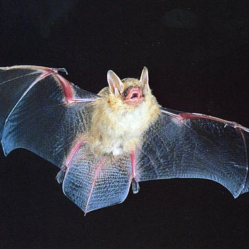
Tricolored Bat
The tricolored bat can be found roosting among White Oaks on the banks of the Potomac in the warm summer months.
These bats, named after their three distinct colors of banded fur, act as natural pest controllers.
Every evening, these bats consume thousands of insects; by regulating the insect population, crops are protected and the need for chemical pesticides that pollute drinking water is reduced.
One of the smallest bat species in North America, measuring only 2 to 3 inches in body length.
Tricolored bats are classified as a state-endangered species due to habitat loss and White-nose syndrome, a fungal disease they pick up in the caves where they hibernate in the winter.

Coastal Plains

The Coastal Plains fall east of the Fall Line and extend towards the coast. Millenia of rising sea levels, shifting sediment, and erosion have shaped the region into the sprawling, flat, sandy landscape it is today. Its wetlands and marshes support a diverse range of plant and animal life.

Atlantic Sturgeon
Dubbed a "living fossil", the Atlantic sturgeon has graced the Earth for over 200 million years. It serves as an important study into the evolutionary history of vertebrates, as well as an important source of food historically.
Indigenous tribes, such as the Patawomeck, relied on the Atlantic sturgeon and long harvested it sustainably.
After European settlement, their existence supported fisheries until they were unfortunately overharvested, and their waters polluted, leading to their spot on the Endangered Species list today.
These behemoths can grow up to 14 feet long and weigh over 800 pounds, living up to 60 years.
The Atlantic sturgeon travels from the Atlantic Ocean through the Potomac River to lay and fertilize their eggs in fresh, inland water. Due to this unique habit of spawning in fresh water, their presence indicates when a river is clean.

Public Access
The Potomac River holds memories for many of us. These activities are possible because of stewardship and work to improve accessibility to the river.

Historically, there has always been an unequal distribution of access to outdoor, open spaces. With this inequability, comes the inherent deprivation of the numerous health benefits nature provides.
"Living in greener urban areas is associated with lower probabilities of cardiovascular disease, obesity, and diabetes.”
Distance to protected land was a category used to determine land NVCT should conserve in the Central Potomac Region. Protecting land near other protected areas creates habitat connectivity and could increase public access opportunities.
By decreasing the distance between people and protected urban green spaces, people have reliable areas for recreation and exercise. In fact, when people exercise outside, they exercise for longer and more intense durations, leading to lower blood pressure and heart rate.

Drinking Water
The Potomac provides drinking water for more than 5 million residents across the region. The health of this river is directly tied to the quality of water we drink. Water treatment centers can get overwhelmed by high demand from population growth and heavy pollution from the surrounding land. An easier and more sustainable solution to providing clean water to Northern Virginia is to take care of the land surrounding our river.

NVCT identified land with qualities needed for watershed protection. This land lies in the Potomac watershed and has features related to watershed health, such as a stream, a wetland, and riparian buffers. When land is developed, it is often converted into impervious surfaces, made of materials that can't absorb water. Instead, these massive amounts of water run off these surfaces and are dumped straight in the river, not allowing any absorption of pollutants such as fertilizers, car oil, and more. Rainfall is channeled here and filtered through the soil before entering the river, and then our glasses.

Soil & Sedment
Soil is our first line of defense.
As water passes through the soil, larger contaminant particles are trapped, preventing them from reaching the river.
Further layers, such as sand, gravel, and rock, further refine the water by picking up fine particular matter.


Development Vulnerability
Northern Virginia is a rapidly expanding region, due in part to the explosion in data center and other technology/energy infrastructure. Once this land is lost, it’s gone forever. Our job is to ensure that land can be protected to prevent any future siting that would erase the land from existence.

Our land of rocky gorges and rolling hills is being converted into housing developments, strip malls, packing garages, and digital infrastructure, erasing the beauty of our region. As the fish and wildlife of the Potomac lose their habitats to deforestation and pollution, we also fall out of balance with nature, losing vital protections.
Over 250+ data centers exist in Northern Virginia, with dozens more on the way.
Our wetlands, trees, and other plants provide a source of air purification. Trees and other vegetation absorb gaseous pollutants, such as carbon dioxide. They convert these storages of carbon into glucose via photosynthesis, which they use for energy, and release pure oxygen back into the atmosphere.
As urbanization expands, not only are we losing the vegetation that purifies our air, but we are producing massive amounts of carbon dioxide, ozone, and nitrogen oxides. Data centers alone produce tens of millions of tons of carbon dioxide annually.
A single mature tree can absorb around 50 pounds of carbon dioxide per year.

Impervious surfaces also do not absorb the sun’s heat and instead re-emit it. Concentrated areas of these surfaces, such as urban zones, with little green spaces are referred to as heat islands, as they can increase the temperature up to 7 degrees during the day, creating deadly conditions.
In 2022 alone, there were 1,578 heat related deaths, out of only 32 states that reported.
Trees and other vegetation prevent heat islands by providing shade that blocks the sun’s rays from hitting asphalt and concrete, common impervious surfaces that re-emit the sun’s heat. Conserving trees also reduces heat islands through evapotranspiration, during which plants pull water from the soil and release it as water vapor, drawing heat and cooling the air.
History
The Potomac River shaped the history of our region. It has sustained life in Northern Virginia since early indigenous peoples began building cultures, traditions, and a way of life tied to it. Before the development of our modern world, the Potomac served as an important trade route for colonists; before that, indigenous hunting trails followed the river's flow. Preserving these historical sites not only preserves our shared history.

Indigenous Origins
The Patawomeck Tribe settled along the Potomac River around 1300 AD, creating villages that surrounded farming, fishing, hunting, and gathering. The tribe practiced sustainable practices such as rotational farming, controlled burns, and diverse planting strategies to achieve balance with the land and maintain biodiversity.
The Patawomecks were a part of the larger Powhatan Federation, an alliance of over 30 Algonquian speaking tribes whose territory stretched the entire Coastal Plain of Virginia. The Patawomecks paid tribute to Cheif Powatahn, head of the Federation chiefdom, for protection.
In an effort to maintain independence, the Patawomecks traded corn and other food provisions with English settlers in exchange for tools and weapons; they later formed a defensive alliance with the English against the Powhatans, refusing to help the Powhatan when they attacked the English.
As the English continued to expand, taking land for farming, the English and Patawomeck’s relationship started to deteriorate. In 1666, the General Council of Virginia declare war against the Patawomeck tribe, slaughtering all of the men of the tribe and selling the women and children into slavery.
The descendants of the survivors of this massacre make up the existing Patawomeck tribe today, who operate in Stafford and King George country, working to preserve their lineage and history, and reconnect with the land.


Get Involved!
Join NVCT in the movement to create a stronger, healthier future for the Potomac and protect nearby nature for generations to come!

Make a gift today and become a member, or reach out to NVCT's Membership Manager, Abby Knipp, to learn more at: aknipp@nvct.org.
Join our volunteer team today and be a part of preserving Northern Virginia’s clean water, land, and character!